Fahrrad
Bilder
- [stvkr-a-fotos] Re: OT: Bodenmarkierungen
geschrieben von Michael Schefbäck am Sa., 03.10.2020 - 12:58
Aufnahmezeitpunkt2020Bild Informationen
Location48° 10' 1" N , 16° 25' 27" ECopyright Notice© Michael SchefbaeckDateigröße253248Breite600Höhe400 - [stvkr-a-fotos] [OT] Radfahranlagen 5/5 Nachtrag
geschrieben von Michael Schefbäck am Fr., 24.06.2011 - 04:23
Aufnahmezeitpunkt2011Bild Informationen
Location48° 10' 20" N , 16° 25' 6" ECopyright Notice© Michael SchefbaeckDateigröße145981Breite640Höhe480 - [stvkr-a-fotos] [OT] Radfahranlagen 5/5 Nachtrag
geschrieben von Michael Schefbäck am Fr., 24.06.2011 - 04:23
Aufnahmezeitpunkt2011Bild Informationen
Location48° 10' 20" N , 16° 25' 7" ECopyright Notice© Michael SchefbaeckDateigröße140217Breite640Höhe480 - [stvkr-a-fotos] [OT] Radfahranlagen 5/5 Radfahrerfeindlichkeit
geschrieben von Michael Schefbäck am Fr., 24.06.2011 - 03:36
Aufnahmezeitpunkt2005-07-24Bild Informationen
Dateigröße494982Breite617Höhe1610 - [stvkr-a-fotos] [OT] Radfahranlagen 4/5 Fehlplanungen
geschrieben von Michael Schefbäck am Fr., 24.06.2011 - 03:36
Bild Informationen
Location48° 10' 20" N , 16° 24' 31" ECopyright Notice© Michael SchefbaeckDateigröße126806Breite640Höhe480 - [stvkr-a-fotos] [OT] Radfahranlagen 4/5 Fehlplanungen
geschrieben von Michael Schefbäck am Fr., 24.06.2011 - 03:36
Bild Informationen
Location46° 50' 15" N , 14° 50' 33" ECopyright Notice© Michael SchefbaeckDateigröße176470Breite640Höhe480 - [stvkr-a-fotos] [OT] Radfahranlagen 4/5 Fehlplanungen
geschrieben von Michael Schefbäck am Fr., 24.06.2011 - 03:36
Bild Informationen
Location48° 12' 25" N , 16° 21' 35" ECopyright Notice© Michael SchefbaeckDateigröße143857Breite640Höhe480 - [stvkr-a-fotos] [OT] Radfahranlagen 3/5 Zweckentfremdung
geschrieben von Michael Schefbäck am Fr., 24.06.2011 - 03:36
Bild Informationen
Location48° 11' 9" N , 16° 22' 28" ECopyright Notice© Michael SchefbaeckDateigröße130175Breite640Höhe480 - [stvkr-a-fotos] [OT] Radfahranlagen 3/5 Zweckentfremdung
geschrieben von Michael Schefbäck am Fr., 24.06.2011 - 03:36
Bild Informationen
Location48° 12' 0" N , 16° 22' 32" ECopyright Notice© Michael SchefbaeckDateigröße123987Breite480Höhe640 - [stvkr-a-fotos] [OT] Radfahranlagen 3/5 Zweckentfremdung
geschrieben von Michael Schefbäck am Fr., 24.06.2011 - 03:36
Bild Informationen
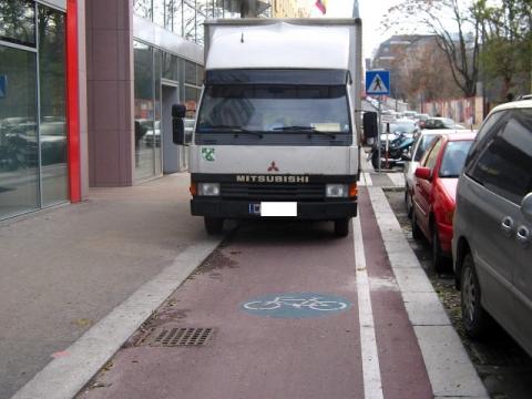
Copyright Notice© Michael SchefbaeckDateigröße175347Breite480Höhe640 - [stvkr-a-fotos] [OT] Radfahranlagen 2/5 Blockierung
geschrieben von Michael Schefbäck am Fr., 24.06.2011 - 03:36
Bild Informationen
Location48° 11' 54" N , 16° 24' 29" ECopyright Notice© Michael SchefbaeckDateigröße111255Breite640Höhe426 - [stvkr-a-fotos] [OT] Radfahranlagen 2/5 Blockierung
geschrieben von Michael Schefbäck am Fr., 24.06.2011 - 03:36
Bild Informationen
Location48° 11' 43" N , 16° 24' 36" ECopyright Notice© Michael SchefbaeckDateigröße139246Breite640Höhe480 - [stvkr-a-fotos] [OT] Radfahranlagen 2/5 Blockierung
geschrieben von Michael Schefbäck am Fr., 24.06.2011 - 03:36
Bild Informationen
Location48° 11' 41" N , 16° 22' 24" ECopyright Notice© Michael SchefbaeckDateigröße128794Breite640Höhe480 - [stvkr-a-fotos] [OT] Radfahranlagen 2/5 Blockierung
geschrieben von Michael Schefbäck am Fr., 24.06.2011 - 03:36
Bild Informationen
Location48° 9' 56" N , 16° 25' 32" ECopyright Notice© Michael SchefbaeckDateigröße153985Breite640Höhe480 - [stvkr-a-fotos] [OT] Radfahranlagen 2/5 Blockierung
geschrieben von Michael Schefbäck am Fr., 24.06.2011 - 03:36
Bild Informationen
Location48° 9' 55" N , 16° 25' 33" ECopyright Notice© Michael SchefbaeckDateigröße130801Breite640Höhe480 - [stvkr-a-fotos] [OT] Radfahranlagen 2/5 Blockierung
geschrieben von Michael Schefbäck am Fr., 24.06.2011 - 03:36
Bild Informationen
Location48° 9' 55" N , 16° 25' 33" ECopyright Notice© Michael SchefbaeckDateigröße151206Breite640Höhe480 - [stvkr-a-fotos] [OT] Radfahranlagen 2/5 Blockierung
geschrieben von Michael Schefbäck am Fr., 24.06.2011 - 03:36
Bild Informationen
Location48° 9' 55" N , 16° 25' 33" ECopyright Notice© Michael SchefbaeckDateigröße131772Breite640Höhe480 - [stvkr-a-fotos] [W] OEBB-Anzeigen, Radwege ...
geschrieben von Michael Schefbäck am Mi., 12.04.2006 - 21:58
Aufnahmezeitpunkt2006Bild Informationen
Location48° 12' 40" N , 16° 23' 8" ECopyright Notice© Michael SchefbaeckDateigröße96355Breite600Höhe450 - [stvkr-a-fotos] Schilderwahn
geschrieben von Michael Schefbäck am Di., 21.03.2006 - 14:46
Aufnahmezeitpunkt2005Bild Informationen
Location47° 3' 59" N , 15° 26' 2" ECopyright Notice© Michael SchefbaeckDateigröße55235Breite600Höhe399 - Re: [stvkr-a-fotos] [OT] Wiedner Hauptstrasse / Radweg am Kap
geschrieben von Michael Schefbäck am Sa., 12.11.2005 - 22:23
Bild Informationen
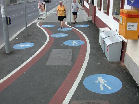
Location48° 12' 37" N , 16° 23' 35" ECopyright Notice© Michael SchefbaeckDateigröße186288Breite600Höhe900 - OT: Bodenmarkierungen
geschrieben von Harald Jahn, Viennaslide am Sa., 04.08.2001 - 17:50
Aufnahmezeitpunkt2001Bild Informationen
Location48° 10' 1" N , 16° 25' 27" EDateigröße105851Breite800Höhe600

